WCS Environmental Trends Analysis Ruaha & Katavi National Parks
Conducting an Environmental Trends Analysis of the Ruaha & Katavi National Parks in Tanzania
Team Members:
Rowan Moody
Caroline Williams
Advisors:
John Rogan (Professor)
Nicholas Geron (Teaching Assistant)
Affiliation:
Clark University
Course:
GEOG 382: Advanced Remote Sensing
Partners:
Wildlife Conservation Society (WCS)
Team Members:
Rowan Moody
Caroline Williams
Advisors:
John Rogan (Professor)
Nicholas Geron (Teaching Assistant)
Affiliation:
Clark University
Course:
GEOG 382: Advanced Remote Sensing
Partners:
Wildlife Conservation Society (WCS)
Project Description:
This project was accomplished alongside Rowan Moody in collaboration with David Wilke and Danielle LaBruna of the Wildlife Conservation Society (WCS). Additionally, John Rogan and Nicholas Geron provided much support and mentorship throughout. Below includes our findings.
Project Objectives:
Study Area:
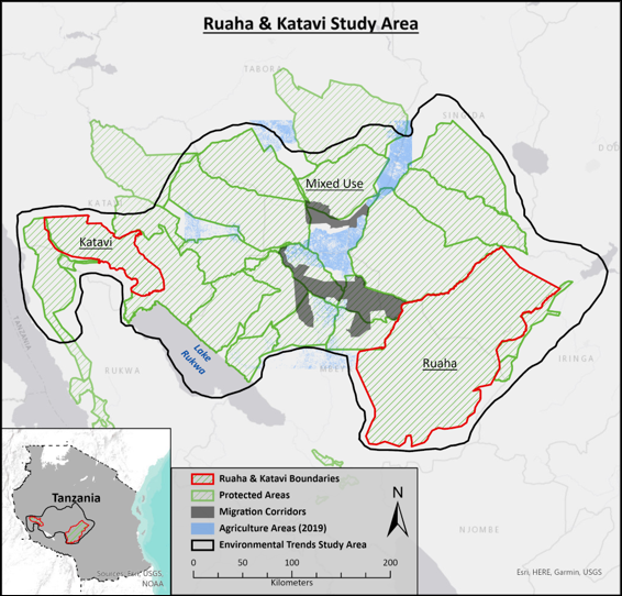
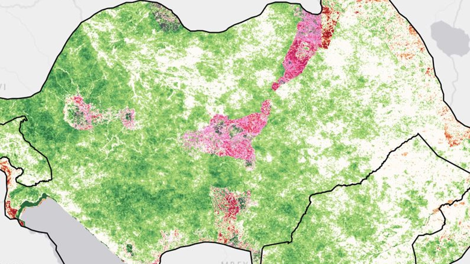
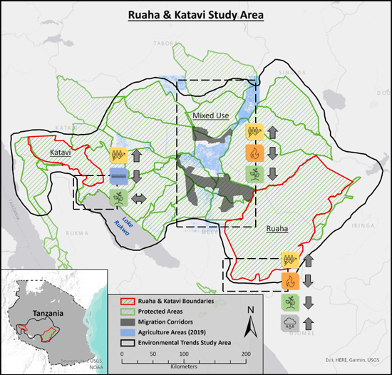
This project examined environmental trends at Ruaha and Katavi National Parks in Tanzania. This map shows protected areas within and surrounding these two parks outlined in red. The map also shows animal migration corridors which sits in between these two study areas. Agricultural Areas are marked in a light blue as well. We examined human population, surface water, wildfire, vegetation, and precipitation trends from 2000 to 2020.
This project examined environmental trends at Ruaha and Katavi National Parks in Tanzania. This map shows protected areas within and surrounding these two parks outlined in red. The map also shows animal migration corridors which sits in between these two study areas. Agricultural Areas are marked in a light blue as well. We examined human population, surface water, wildfire, vegetation, and precipitation trends from 2000 to 2020.
Data:
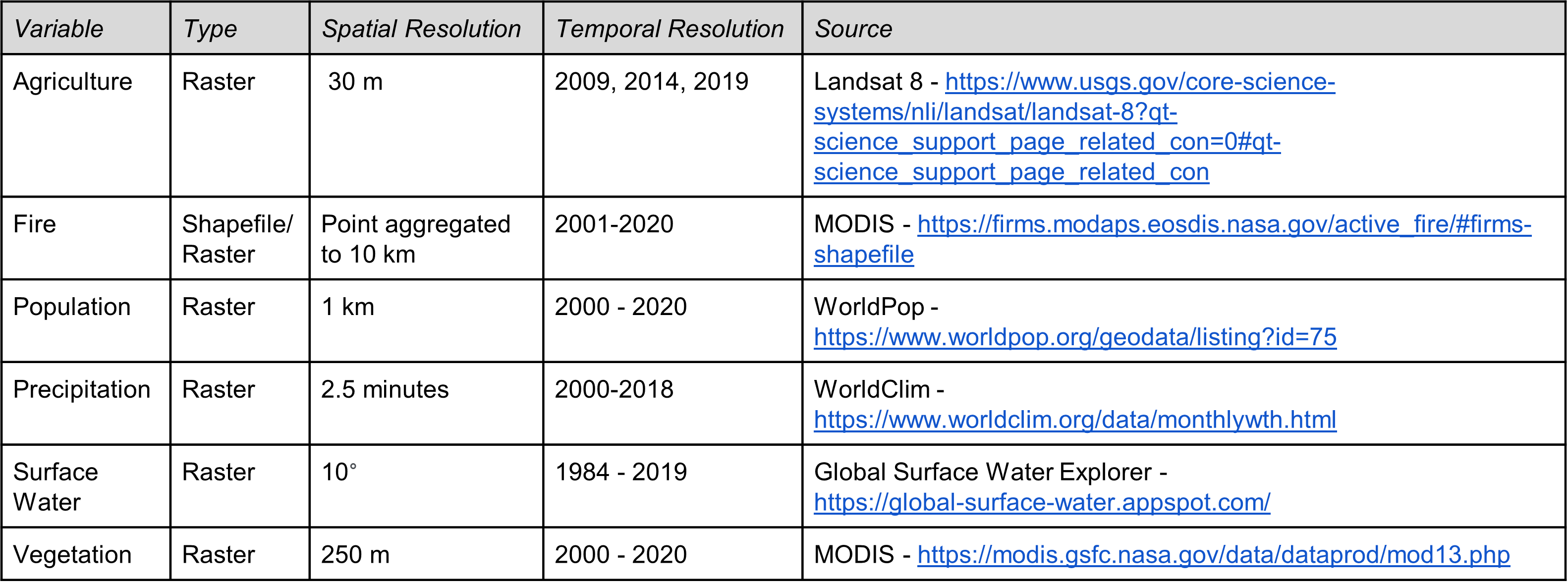
We utilized a variety of data sources for plotting agricultural lands and examining trends in Ruaha and Katavi National Parks. Terra MODIS was used for fire and parameters like the Enhanced Vegetation Index (EVI). We also used WorldPop and WorldClim for population and precipitation, respectively. Lastly, we used the joint research centre (JRC) occurrence dataset to monitor trends in surface water.
Methods:
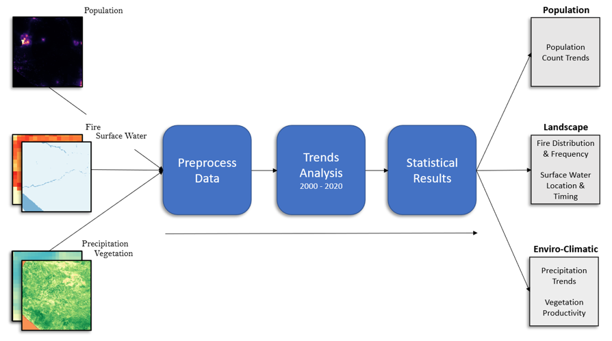
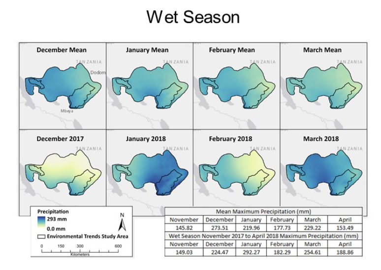
Our analysis included preprocessing the datasets for each variable. We then examined trends from 2000 to 2020 using various software packages and statistical analyses. We used TerrSet Earth Trends Modeler (ETM) to examine monthly trends in precipitation and vegetation. We used the Mann-Kendall statistic for monotonic trends and Theil-Sen Median trends analysis as well. To visualize our results, we created report cards showing changes in increase, no change, or decrease in these variables for each national park and the mixed use areas in between them.
Results:
The results show trends in population, wildfire, vegetation, surface water, and precipitation. This includes spatial representations in trends as well as over time.
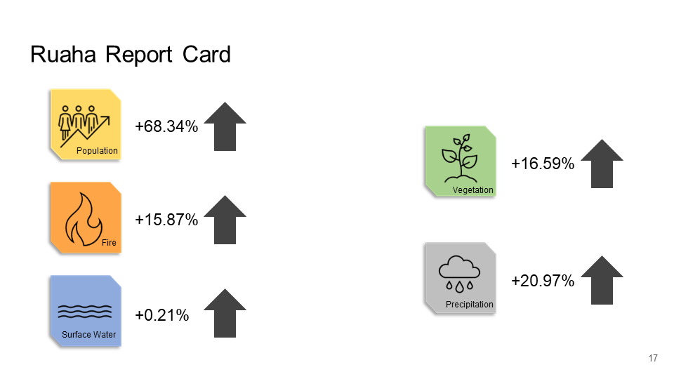
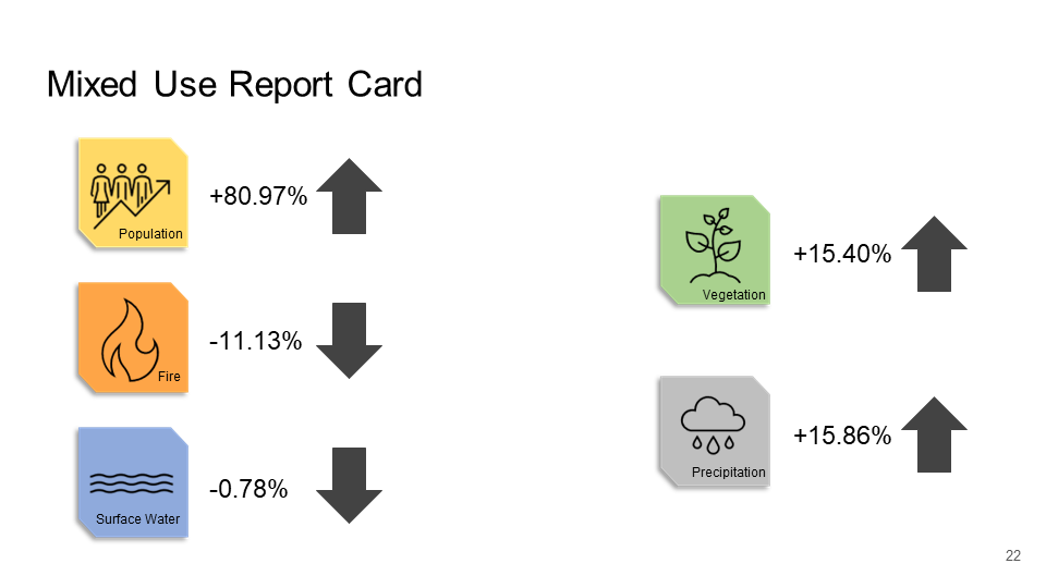
Report Cards:
The report cards are shown for the Ruaha and Katavi National Parks as well as Mixed Use areas. This shows percent change (increase, no change, decrease) for each variable of interest.

Conclusions:
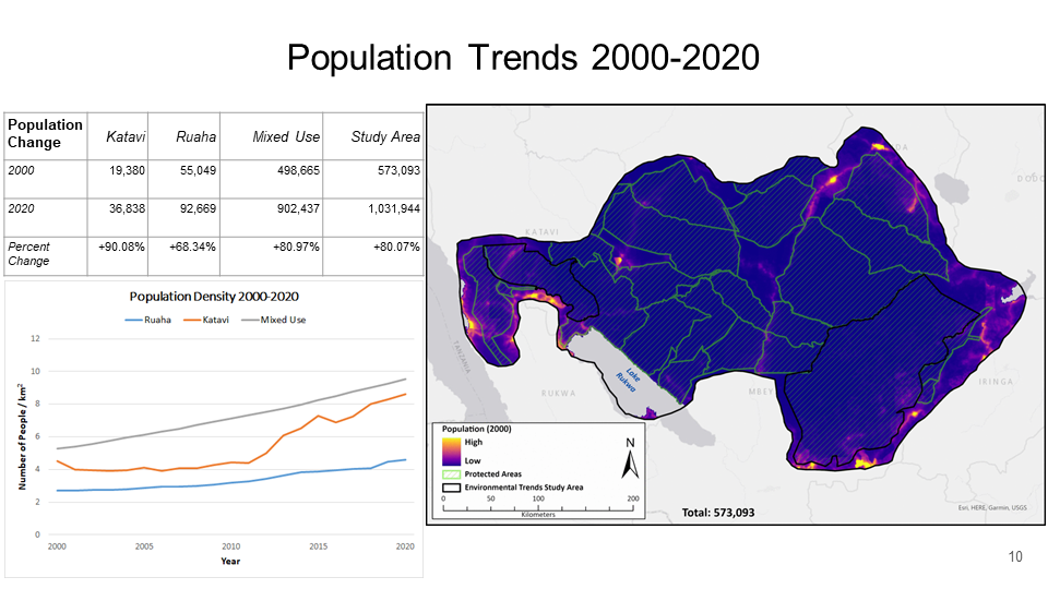
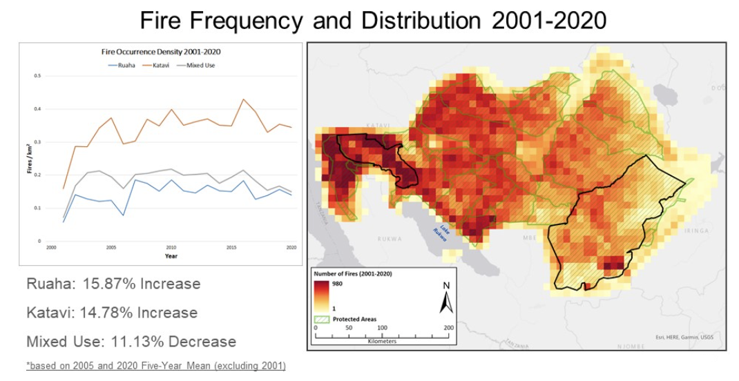
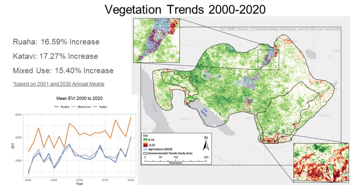
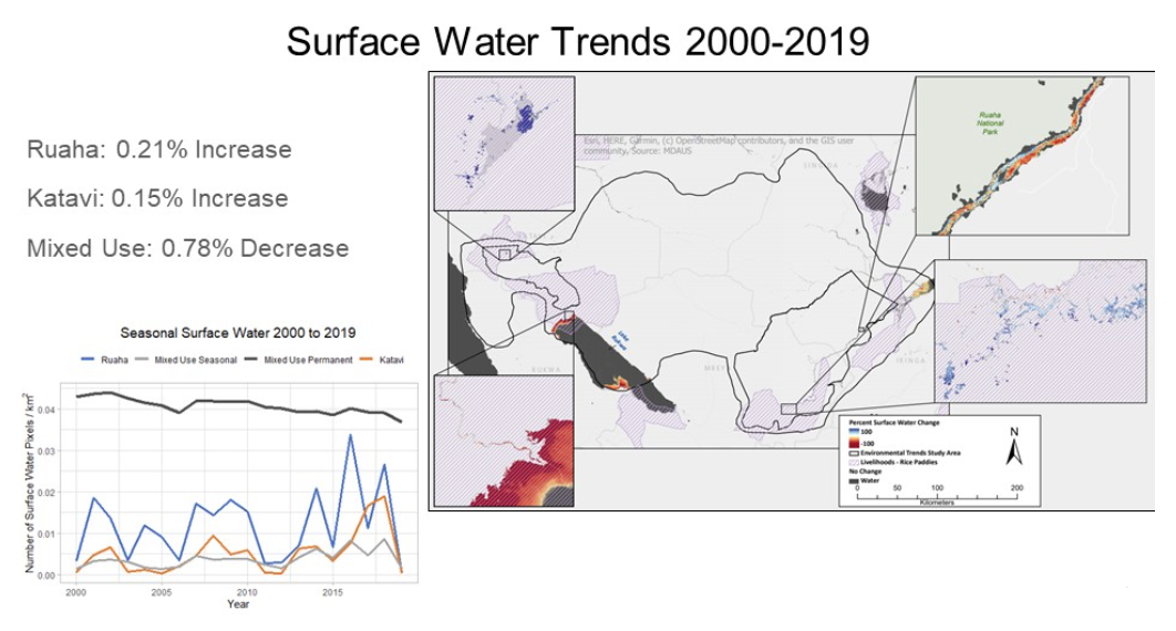
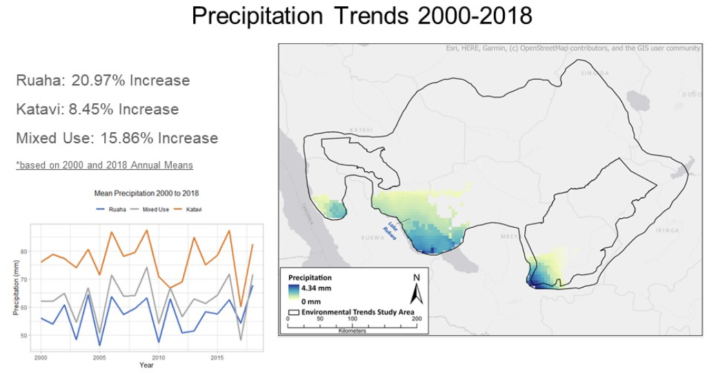
Ruaha and Katavi National Parks are experiencing an increasing trend across all variables included in this study.
Increases in population, fire, and vegetation are especially prominent in Katavi, meanwhile Ruaha is demonstrating a high increase in precipitation and surface water.
The Mixed Use area is showing both increasing and decreasing trends across the landscape. Specifically, there is a notable decrease in fire and surface water.
This project examined environmental trends at Ruaha and Katavi National Parks in Tanzania. This map shows protected areas within and surrounding these two parks outlined in red. The map also shows animal migration corridors which sits in between these two study areas. Agricultural Areas are marked in a light blue as well. We examined human population, surface water, wildfire, vegetation, and precipitation trends from 2000 to 2020.
Code:
Project Deliverables:
Please feel free to contact me through my LinkedIn Account below.